Save this image free of charge
in 800 pixels for layout use
(right click, Save as...)
|
|
Ref : V01764
Theme :
Looking at Earth - Faults (69 images)
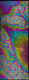
Title : San Andreas Fault, Southern California, Radar Image,
Caption :
This topographic radar image vividly displays California's famous San Andreas Fault along the southwestern edge of the Mojave Desert, 75 kilometers (46 miles) north of downtown Los Angeles. The entire segment of the fault shown in this image last ruptured during the Fort Tejon earthquake of 1857. This was one of the greatest earthquakes ever recorded in the U.S., and it left an amazing surface rupture scar over 350 kilometers in length along the San Andreas. Were the Fort Tejon shock to happen today, the damage would run into billions of dollars, and the loss of life would likely be substantial, as the communities of Wrightwood, Palmdale, and Lancaster (among others) all lie upon or near the 1857 rupture area. The Lancaster/Palmdale area appears as bright patches just below the center of the image and the San Gabriel Mountains fill the lower left half of the image. At the extreme lower left is Pasadena. High resolution topographic data such as these are used by geologists to study the role of active tectonics in shaping the landscape, and to produce earthquake hazard maps.This image combines two types of data from the Shuttle Radar Topography Mission. The image brightness corresponds to the strength of the radar signal reflected from the ground, while colors show the elevation as measured by SRTM. Each cycle of colors (from pink through blue back to pink) represents an equal amount of elevation difference (400 meters, or 1300 feet) similar to contour lines on a standard topographic map. This image contains about 2400 meters (8000 feet) of total relief.The Shuttle Radar Topography Mission (SRTM), launched on February 11, 2000, uses the same radar instrument that comprised the Spaceborne Imaging Radar-C/X-Band Synthetic Aperture Radar (SIR-C/X-SAR) that flew twice on the Space Shuttle Endeavour in 1994. The mission is designed to collect three-dimensional measurements of the Earth's surface. To collect the 3-D data, engineers added a 60-meter-long (200-foot) mast, an additional C-band imaging antenna and improved tracking and navigation devices. The mission is a cooperative project between the National Aeronautics and Space Administration (NASA), the National Imagery and Mapping Agency (NIMA) and the German (DLR) and Italian (ASI) space agencies. It is managed by NASA's Jet Propulsion Laboratory, Pasadena, CA, for NASA's Earth Science Enterprise, Washington, DC.Size: 144 km (90 miles) x 52 km (32 miles) Location: 34.5 deg. North lat., 118.3 deg. West lon.Orientation: North toward upper right Original Data Resolution: 30 meters (99 feet) Date Acquired: February 16, 2000
|
|

